HP Prime Software
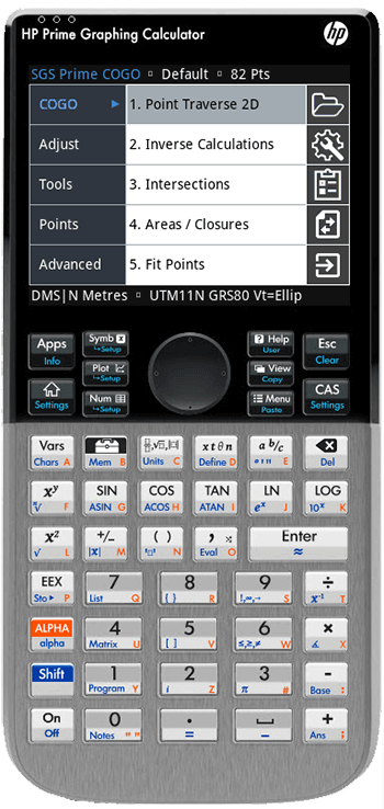
SGS Prime COGO
SGS Prime COGO is available in English, French, German, Spanish and Portuguese languages, full support for other languages can be added with the help of a translator. The software licensing options include Lite, Standard or Professional versions.
Feature Comparison
Compare the features available with each version of SGS Prime COGO and view a summary of the included features.
Videos
- Installation Overview
- Update Overview
- Introduction / Getting Started
- ASCII File Transfers Overview
- Point Traverse 2D Tutorial
Subscribe to our YouTube Channel to receive notifications of new videos.
Downloads
The recommended HP Prime firmware version is 2.4 (2025-09-15) for both G1 and G2. If your Connectivity Kit does not automatically find the latest firmware update; you may need to update your Connectivity Kit software manually by downloading the latest version from Moravia Consulting.
HP Software
The HP Prime is available as a physical calculator and as virtual calculators for various platforms. The following virtual calculators are able to run SGS Prime COGO:
- Windows Virtual Calculator (Free)
- Windows UWP HP Prime Pro app
- Android HP Prime Pro app
- iOS HP Prime Pro app
- MacOS Virtual Calculator (Free)
NOTE: The HP Connectivity Kit software is required to install SGS Prime COGO, and is available for both Windows and Mac.
License Terms
Before you buy
- Review the Features summary to determine which version of SGS Prime COGO best suits your needs.
- Download the installation files from the Downloads section.
- Install the software on your calculator or virtual calculator. Instructions are available from the Documentaion section.
- Preview the software in the available DEMO mode at no charge.
Terms
When you purchase a SGS Prime COGO license; you receive a license key by e-mail that unlocks the software to function on your device.
- The key is valid for all releases of the same main version. For example, a license key for 1.0 will also work for with 1.1, 1.2, etc. and these updates may be installed at no charge.
- Each license includes the ability to unlock the software on two devices:
- One HP Prime Calculator
- One HP Prime Virtual Calculator (Windows, Mac, iOS or Android)
- Technical support is included with your purchase at no additional charge.
Buy Now
Choose the license to purchase, and enter the SGS Prime COGO Device ID of your HP Prime calculator (or virtual calculator) in the box provided, then click the "Buy Now" button. The transaction will be completed on the PayPal hosted pages that follow.
A PayPal account is optional, and not required to complete a "Buy Now" transaction.
The required Device ID is displayed by the software after installation. Please download and install the app prior to purchasing a license.

NOTE: We accept Interac e-Transfer from customers in Canada. Email sales@sgss.ca if you prefer to use this payment method.
Upgrades
If you previously purchased a version of SGS Prime COGO and find you require more functionality; a license upgrade can be purchased for the difference in cost of the licenses.
Dealers
Purchase SGS Prime COGO and a HP Prime Graphing Calculator directly from one of our dealers:
| Dealer | Country | Website |
|---|---|---|
| CalculatorSource | USA | www.calculatorsource.com |
| Calculator World | Australia | https://calculatorworld.com.au |
We are looking for dealers worldwide. Email sales@sgss.ca for more information about becoming a dealer.
SGS Prime COGO Feature Summary
Below are brief descriptions of all the functions available in SGS Prime COGO. The software is available at a Lite, Standard , or Professional license level.
COGO Menu |
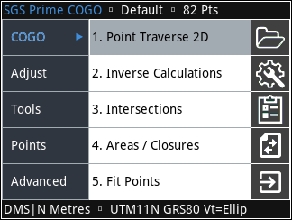 |
| Point Traverse 2D | Lt | Std | Pro |
|---|---|---|---|
| Standard Mode - Calculate coordinates by direction, distance and optional offset. | ✔ | ✔ | ✔ |
| Angle Right Mode - Calculate coordinates by turned angle from backsight, distance and optional offset. | ✔ | ✔ | ✔ |
| Plus Mode - A complete COGO solution for calculating coordinates by distance and direction, intersection calculations, and inverse calculations. | ✔ | ✔ | ✔ |
| Curve Mode - Calculate coordinaes relative to a curve radius point and another point on the curve. | ✔ | ✔ | ✔ |
| Inverse Calculations | Lt | Std | Pro |
|---|---|---|---|
| Inverse Points - Find the direction, horizontal and slope distances, slope and coordinate differences between two points. Calculation methods include Point to Point, Radial Ties (to calculate inverses to multiple points from a base point), and Point Chain (to calculate inverses of sequential courses). The Point to Point option allows the user to calculate coordinates of any station and offset between the two points, calculate multiple points by distance interval and offset, or by equal partition and offset. | ✔ | ✔ | ✔ |
| Inverse Curve (Radial Point) - Find all the curve elements by entering points at the beginning and end of the curve, the radius point and the direction of the curve. Calculate coordinates of any station and offset along the curve, calculate multiple points by distance interval and offset, or by equal partition and offset. | ✔ | ✔ | ✔ |
| Inverse Curve (Three Point) - Find all the curve elements by entering points at the beginning and end of the curve, and a third point on the curve. Calculate coordinates of any station and offset along the curve, calculate multiple points by distance interval and offset, or by equal partition and offset. | ✔ | ✔ | ✔ |
| Inverse Angle - Calculate the turned angle at a station by entering the station, backsight and foresight points. Distances to both backsight and foresight are also calculated. | ✔ | ✔ | ✔ |
| Inverse Point to Line - Enter 2 points along a baseline and a offset point to calculate the offset distance perpendicular to the line, the distances along the baseline that the offset point is perpendicular. | ✔ | ✔ | ✔ |
| Inverse Point to Curve - Enter beginning of curve and end of curve points, a radius point and a offset point to calculate the offset distance perpendicular to the curve, the distances along the curve that the offset point is perpendicular. | ✔ | ✔ | ✔ |
| Inverse Point to Alignment - Select a pre-defined alignment and enter a single point or a range of points to inverse to the alignment. A maximum horizontal offset may be specified to ensure the point offset information is applied to the correct segment. Results may be exported in CSV or HTML format. | — | — | ✔ |
| Intersections | Lt | Std | Pro |
|---|---|---|---|
| Bearing-Bearing - Intersect directions from two known points. Perpendicular offsets can be entered for both directions. | ✔ | ✔ | ✔ |
| Bearing-Distance - Intersect a direction from a known point, with a distance to another known point. A perpendicular offset can be entered for the direction. | ✔ | ✔ | ✔ |
| Distance-Distance - Intersect distances from two known points. | ✔ | ✔ | ✔ |
| Distance-Interior Angle - Intersect a distance from a known point with an angle to another known point. | ✔ | ✔ | ✔ |
| Areas / Closures | Lt | Std | Pro |
|---|---|---|---|
| Area by Points - Calculate the area of a polygon by entering the points along the perimeter. Curved and straight segments can be entered. The polygon is drawn on the screen, and can be exported as a DXF file. | ✔ | ✔ | ✔ |
| Subdivide by Sliding Bearing - Subdivide a specified area by sliding a line of fixed bearing. Solution points can be stored, and the calculated polygon can be exported as a DXF file. | — | ✔ | ✔ |
| Subdivide by Hinge Point - Subdivide a specified area by swinging a line from a hinge point into another line of fixed bearing. Solution points can be stored, and the calculated polygon can be exported as a DXF file. | — | ✔ | ✔ |
| Closures - Calculate closures by entering dimensions of straight and curved segments. The report includes the precision, length, area and misclose information. Results can be exported to a text file, a HTML report, a DXF file, or points stored in the project database. | — | ✔ | ✔ |
| Quick Closure - Quickly calculate closures without using points or coordinates. Solves for missing dimensions. | ✔ | ✔ | ✔ |
| Fit Points | Lt | Std | Pro |
|---|---|---|---|
| Fit to Straight Line - Calculate the least squares line that best fits a series of points (linear regression). The direction (azimuth/bearing) of the line and its standard deviation, the Y-Intercept and its standard deviation, and correlation are calculated. Perpendicular offsets can be viewed for each point and the points can be shifted to fall on the line. | — | ✔ | ✔ |
| Fit to Circular Curve - Calculate the radius and the coordinates of the radius point of the least squares circle that best fits a series of points. When providing points along one or both tangents, the program will also solve the BC and/or EC point coordinates. It is possible to enter a radius for the curve that differs from the best-fit radius and recalculate a new least squares circle with the fixed parameter. Radial offsets can be viewed for each point, and the points can be shifted to fall on the curve. | — | ✔ | ✔ |
| Double Proportion - Enter the 4 points for the North, East, South and West section corners and the record measurements to the lost section corner to calculate the coordinates as per the Double Proportionate Measurement method (BLM). | — | ✔ | ✔ |
| Irregular Boundary - A combination of single proportion and compass rule is used to re-establish a lost corner as per the Irregular Boundary Adjustment method (BLM). | — | ✔ | ✔ |
| Grant Boundary - Calculate the positions of lost angle points as per the Grant Boundary Adjustment method (BLM). | — | ✔ | ✔ |
Adjust Menu |
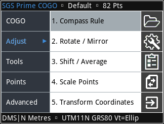 |
| Compass Rule | Lt | Std | Pro |
|---|---|---|---|
| Closed Figure - Perform a compass rule adjustment on a series of points in a closed loop. The precision, perimeter and misclose information is calculated. Review pre- and post-adjustment course dimensions and optionally adjust the point coordinates. | ✔ | ✔ | ✔ |
| Close to Fixed point - Perform a compass rule adjustment on a series of points closing on a fixed point. The precision, length and misclose information is calculated. Review pre- and post-adjustment course dimensions and optionally adjust the point coordinates. | ✔ | ✔ | ✔ |
| Rotate / Mirror | Lt | Std | Pro |
|---|---|---|---|
| Rotate around Base Point - Rotate a series of points around a specified base point by a entered or calculated angle. | ✔ | ✔ | ✔ |
| Rotate around Origin (0,0) - Rotate a series of points around a 0,0 by a entered or calculated angle. | ✔ | ✔ | ✔ |
| Mirror along Baseline - Mirror a series of points along a baseline as defined by two points. | ✔ | ✔ | ✔ |
| Shift / Average | Lt | Std | Pro |
|---|---|---|---|
| Shift by ΔX/ΔY/ΔZ - Shift a series of points by entering northing/easting/elevation shift values. | ✔ | ✔ | ✔ |
| Shift by Distance and Direction - Shift a series of points by entering distance and direction shift values. | ✔ | ✔ | ✔ |
| Shift by From/To Points - Shift a series of points by entering two points to shift from/to. | ✔ | ✔ | ✔ |
| Average Points - Compute the average coordinate values of a series of points. The standard deviations of the averaged coordinates, and the coordinate ranges are calculated. | ✔ | ✔ | ✔ |
| Scale Points | Lt | Std | Pro |
|---|---|---|---|
| Scale from Base Point Scale a series of points from a base point by specified horizontal and vertical scale factors. | ✔ | ✔ | ✔ |
| Scale from Origin (0,0,0) Scale a series of points from 0,0,0 by specified horizontal and vertical scale factors. | ✔ | ✔ | ✔ |
| Transform Coordinates | Lt | Std | Pro |
|---|---|---|---|
| Helmert Transformation - Transform a series of points from one coordinate system to another by matching up control points in both systems. Points may be matched up 1D, 2D or 3D and the scale factor may be fixed at 1. The least squares solution computes the origin shift of the transformation, rotation and scale factor parameters, the standard deviation in the northing/easting, the elevation shift and the residuals for each control pair. | — | ✔ | ✔ |
| 3D to Plan Cross Section - Transform 3D point coordinates to 2D cross section points along a cut line as defined by two points. | — | ✔ | ✔ |
Tools Menu |
 |
| Triangle Solver | Lt | Std | Pro |
|---|---|---|---|
| Plane Triangle Solver - Solve the remaining parts, area and perimeter of any plane triangle when providing 3 known parts. | ✔ | ✔ | ✔ |
| Horizontal Curves | Lt | Std | Pro |
|---|---|---|---|
| Circular Curve Solver - The circular curve solver solves all the curve parameters when two parameters are provided, with one known parameter being either the radius or deflection angle, or provide the arc length and chord length to solve using Newton's method. Tangent offset and sub-chord information can be calculated by station or by interval from the solution. | ✔ | ✔ | ✔ |
| Curve Through Fixed Point - Solves a curve that is required to fit fixed tangents and a fixed point on the curve. | ✔ | ✔ | ✔ |
| Spiral Curve Solver - The spiral curve solver solves all the parameters of a spiral-curve-spiral (equal spiral) transition curve when the spiral length, total SCS deflection angle and curve radius are provided. | — | ✔ | ✔ |
| Vertical Curves | Lt | Std | Pro |
|---|---|---|---|
Vertical Curve Solver - Solve a vertical curve by entering grades or elevations. Fixed point vertical curves and slope intersections are also included. Solve the elevation of any point or interval along the curve, or solve for the station with a given elevation.
|
✔ | ✔ | ✔ |
| RPN Calculator | Lt | Std | Pro |
|---|---|---|---|
| RPN Calculator - RPN Calculator designed for survey calculations. Common distance/angle/area/volume unit support is included for direct calculations without the need to convert values prior to calculations. | ✔ | ✔ | ✔ |
| Configure Settings | Lt | Std | Pro |
|---|---|---|---|
| User Settings - Angle and Distance Units, Coordinates, Stations and Grades formats, Input and Output Scale Factors, general Program options, DXF export layers, and Coordinate System settings can be configured to the user's preference. | ✔ | ✔ | ✔ |
Points Menu |
 |
| Store and Edit Points | Lt | Std | Pro |
|---|---|---|---|
| Store and Edit Points - Store and edit point coordinates in the current project database. | ✔ | ✔ | ✔ |
| Delete Points | Lt | Std | Pro |
|---|---|---|---|
| Delete Points - Delete points from the current project database. | ✔ | ✔ | ✔ |
| Renumber Points | Lt | Std | Pro |
|---|---|---|---|
| By Starting Number - Enter a Start ID and a range of points to renumber. | ✔ | ✔ | ✔ |
| By Additive Number - Enter a additive number and a range of points to renumber. | ✔ | ✔ | ✔ |
| Plot Points | Lt | Std | Pro |
|---|---|---|---|
| Plot Points - Graphically display a range of points on the screen. Touch and keyboard navigation (pan/zoom) is possible. | ✔ | ✔ | ✔ |
| Import / Export | Lt | Std | Pro |
|---|---|---|---|
| Import ASCII Points - Import comma, space or tab delimited ASCII files. | — | ✔ | ✔ |
| Export ASCII Points - Export comma, space or tab delimited ASCII files, and choose the number of decimals. | — | ✔ | ✔ |
| Export DXF Points - Export DXF files of points in the project database to open directly in a CAD program. | — | ✔ | ✔ |
| Export KML Points - Export KML files of points in the project database to view in Google Earth. Point information balloons feature a point finder link to navigate to the point with your mobile device. | — | — | ✔ |
Advanced Menu |
 |
| Alignments | Lt | Std | Pro |
|---|---|---|---|
Alignments - Create multiple complex 3D alignments with fully editable segments. The horizontal component of an alignment may include straight, curve, and spiral-curve-spiral segments. Vertical curves and straight grades can be used to define the vertical component, and cross section templates can be defined and assigned to portions of, or the whole alignment. Station equations are supported.
|
— | — | ✔ |
| Leveling | Lt | Std | Pro |
|---|---|---|---|
Leveling - Create multiple Leveling projects with fully editable observation data.
|
— | — | ✔ |
| Traverse Plus 3D | Lt | Std | Pro |
|---|---|---|---|
Traverse Plus 3D (BETA) is included in Version 1.5.0. Re-create coordinates from field notes or simulate data collection and field calculation procedures.
|
— | — | ✔ |
| Coordinate Converter | Lt | Std | Pro |
|---|---|---|---|
The Coordinate Converter features the following capabilities:
|
— | — | ✔ |
| Ellipsoid Calculations | Lt | Std | Pro |
|---|---|---|---|
| DIRECT and INVERSE Computations are implemented using Vincenty's equations. Position input for both types of calculations can be grid coordinates (N,E,h), geodetic coordinates (Φ,λ,h), cartesian coordinates (x,y,z), or grid coordinates from a point in the database. | — | — | ✔ |